09 May Critical (foundational) spatial data
Challenge
It is timely to consider redefining and expanding the existing list of Foundation Spatial Data Framework themes and the systems that support their creation and use to ensure they are optimised for three and four dimensional needs for a future sensor and information powered world. Migration of thought from the more traditional spatial data infrastructure concepts of data storage and access, to more advanced capabilities including automatically creating, sharing, curating, delivering, and using knowledge (not just data or information) in support of the emerging digital economy and the rise of spatially-aware and equipped citizens must occur. It advances the thinking from information product generation to the production of insights. It also embodies the provisioning of predictive analytics capacity in real-time for any user in any location whilst mobile.
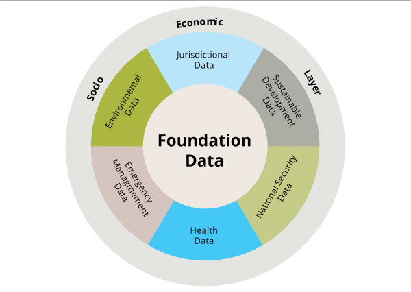
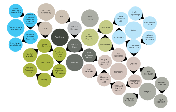
ANZLIC defines Foundation Spatial Data as the authoritative geographic information that underpins, or can add significant value to, any other information; and supports evidence-based decisions across government, industry and the community. These data can be described as base spatial layers required by most users and are generally not derived from other spatial layers. They are authoritative, accurate, and easily discoverable and accessible. Traditionally these data are held and maintained by Government although this is changing. In Australia these tend to be maintained by state governments and aggregated to a national level through the foundation spatial data framework (FSDF) which provides a common reference for the assembly and maintenance of these data to serve the widest possible variety of users. The FSDF aims to deliver a national coverage of the best available, most current, authoritative source of foundation spatial data which is standardised and quality controlled. The data themes are: Address, Administrative Boundaries, Positioning, Place Names, Property, Imagery, Transport, Elevation and Depth, and Land Cover and Land Use.

Figure 8: Conceptual View of Foundation Spatial Data Framework (Source: ANZLIC)
They are managed as a suite of datasets by custodians across government, coordinated through ANZLIC.

Figure 9: FSDF Defined Themes and Datasets (Source: ANZLIC)
However, the ten FSDF themes listed above were established about a decade ago. There has been subsequent work at a global level towards the Sustainable Development Goals (SDG’s), by the United Nations Committee of Experts on Global Geospatial Information Management (UNGGIM). In 2018 they determined the global fundamental geospatial data themes as: Global Geodetic Reference Framework; Addresses; Buildings and Settlements; Elevation and Depth; Functional Areas; Geographical Names; Geology and Soils; Land Cover and Land Use; Land Parcels; Ortho- imagery; Physical infrastructure; Population Distribution; Transport Network; and Water.
It is timely to consider redefining and expanding the existing list of FSDF themes to align with those of the SDG’s, and consider those which will provide for future challenges of three and four dimensions. Several jurisdictions already have work underway, however this has not yet had national agreement. ANZLIC has identified as one of its 2020-24 strategic priorities the modernisation of the FSDF and specifically:
- Modernise foundation spatial data to 3D and 4D (time) digital formats.
- Streamline processes to collect and supply spatial data to users across the full data lifecycle: capture, procure, access, standardise, maintain and value-add.
- Enable better data management practices, focusing on governance, privacy and cyber security, discoverability and accessibility.
- Drive development and adoption of open spatial data standards that align with and inform international standards.
OPPORTUNITY FOR GROWTH
- Future proofing the FSDF data themes by expanding them to account for a future with operating digital twins and applications which will be built on emerging technologies such as edge computing.
- Expanding the FSDF to be able to operate in real or near real time and service digital twins and related priority applications. This will include improving processes which automate the collection, distribution and display of data. This also includes factoring in the development of analytics onboard satellites to optimise near-real time processing and availability
- Flexible governance frameworks and IT infrastructures which authenticate private and community data providers. Government will need to be inclusive of trusted private data providers, such as utilities.
- Building community awareness to further enable FSDF like data sets currently locked up and not being used, to enhance utility of current data sets.
Ensuring that ML/AI, and other new technology developments are optimally used in the creation of FSDF.
ACTIONS
1. Establish a working group to further explore the opportunities for growth comprising GA and FrontierSI.
2. Map needs of sectors and organisations that service Australia’s critical infrastructure and systems of national significance (as defined by the Department of Home Affairs) against what the FSDF can provide in its current and in future forms. To be undertaken by the Space Cross-sectoral Interest Group under the guidance of the Department of Home Affairs and the Australian Space Agency.


